Thursday, July 5, 2012

The new Wild Cascades is now online!

Check out the latest issue of TWC, in color PDF!

http://www.northcascades.org/public_html/TWC-Spring-2012.pdf


In This Issue:
  • NCCC leadership changes mean new roles for Forsgaaard, Zalesky
  • Reiter Forest non-motorized trail development continues
  • Alternative C is NCCC's choice for Suiattle River road project
  • Catalyst makes debut 
  • NCCC Actions, January – April 2012
  • In Memoriam: John Edwards
  • Bumping Lake Update 
  • A conversation with Jan Henderson, Part 2 
  • National Park retirees speak out on H.R. 1505

Monday, June 11, 2012

Dam the North Fork Snoqualmie for a few kilowatts? Don't let it happen! Attend a meeting on the 19th!

FERC staff will be out from DC and it's the ONE AND ONLY time you can make an impression on them in person on the value of this river.


Daytime Scoping Meeting
Date and Time: Tuesday, June 19, 2012, 11:00 a.m.

Virtual Site Review
Date and Time: Tuesday, June 19, 2012, 2:00 p.m.

Evening Scoping Meeting
Date and Time: Tuesday, June 19, 2012, 6:00 p.m.

Location for all meetings:
Cedar River Watershed Education Center Auditorium,
19901 Cedar Falls Road SE, North Bend, WA  98045

More background here and scoping document are here:

http://www.americanwhitewater.org/content/Article/view/articleid/31412/

Monday, May 21, 2012

Interpretive Center opens June 9th at Twisp

Tom and I got a request for the use of our photos of Tower Creek today from "Twisp Works." Turns out there's a new interpretive center opening on the east side of the North Cascades, in the town of Twisp on Hwy 20, and one of their displays is about the geology of the North Cascades. They were looking for a picture of a classic U-shaped glacial valley, that are common in the Cascades. They found this blog and liked our pictures of Tower Creek, at the headwaters of the Methow. It is a classic glacial valley. To see it from this perch you have to hike the PCT as my brother and I did to the point about halfway between Harts Pass and Rainy Pass, then ascend a side trail to Snowy Lakes (spectacular in themselves) then ascend that much elevation again on a steep scree field to the knife-edge of the Cascade Crest itself and look over the rim. That's the vantage point from which I took my version of the photo:


The new interpretive center is where our photo(s) will be exhibited, and it's opening June 9th -- they have a full weekend of events  --  check out their website: http://twispworks.org/methow-valley-interpretive-center

Sunday, April 29, 2012

Snow Report April 20-21, 2012


Time for a snow report.

As you can see from the attached photos, and the gallery linked below, the snowpack is very healthy this year. At mid and low elevations, I'd venture the snowpack is 150 -200 of "normal". Higher elevations APPEAR to be in the 120% range, but could be more. What is notable is that it's been a cool, wet spring, so the upper elevations continue to hold huge amounts of snow that might otherwise have avalanched already.

It was very ominous that in four of the most dangerous avalanche chutes we crossed, only two had debris in them. My take on the situation is that there is still a ton of snow loading the upper reaches of all the peaks, so the chutes are empty not because there wasn't/isn't enough snow, it's that the big events have yet to happen.**
The debris filling Midas/Boston was a 10' high wall of basketball -to-shopping cart sized blocks of snow that measured 200 feet wide. It was a treacherous crossing--very unstable, unpleasant, unnerving.

There has been much angst about "access" and opening roads or closing them. My experience is to be thankful that this road is currently closed by snow. The Mrs. and I snowshoed four miles with full packs to reach camp--a tough first overnighter of the year, but also glorious. We access this area in spring because the road IS closed and we have the opportunity to experience the sights and sounds of an amazing place free of RVs and SUVs! Nothing like the lilting call of the Varied Thrush, and the rush of the Cascade River to carry one along on a restful afternoon nap. We didn't see another person the entire weekend (until hiking out, almost to the National Park boundary).

We did see and hear plenty of avalanches, including one big one at about 11PM off Cascade that shook the valley for a good five minutes. Filmed another off the "usual" W chute of J-burg at about 10 Sunday morning--respectable size, but certainly not Mr. Big, nor the Big One. It was big enough that Athena menionted it reminded her of a shuttle launch! The overnight hours were filled with the crash and roar of small events near and far. We also saw and heard thousands of migrating Canada geese. They were flying well above the summits--probably 12,000' in altitude, yet we could clearly hear them honking to each other as they formed and reformed their V formations. Wow!

We will continue to visit this place as long as the road is closed to motor vehicles, and there is snow to avalanche...

**I've mentioned the snowpack is highly stratified throughout my winter reports. It well may be that there are no true "Climax Avalanches" this year because the snowpack will slab and fracture in a progressive fashion, unloading in an exfoliating manner. Then again, some of those layers are so thick, avalanches may be very similar to climax events even if they don't slide from base/ground.

See
https://picasaweb.google.com/116543602651852680619/NorthForkCascadeRiver12042122?authkey=Gv1sRgCMbQ-Yfq-rmk1gE&feat=email#

Wednesday, April 18, 2012

Suiattle field trip

As the comment deadline loomed, we took another close look at the sad old Suiattle road last Sunday. It further convinced us that ALTERNATIVE C is the way to go, with modifications...

The road is great fun on a mountain bike. Lots of quiet places to pause and contemplate the beautiful old forest and very active braided river channel along the way. There are a few long straight stretches where you can't help but wish the road planners had had a little more imagination than to just lay a ruler down and draw a line, but there are some more interesting stretches in the last 4 miles we recommend for permanent closure.

The slide at MP 12.6, a lot like one later at 20.8, is unstable. Unlike 20.8, though, this one is so far down-valley it does need to get rebuilt - closing it this far down would severely limit motorized access to the valley. But the original rebuild plan calls for a bypass that would mean a huge disturbance of the nearby forest. The bedrock exposed along the river bank, well above ordinary high water, would probably support some of those wire baskets full of rocks to build a bulwark against the river to stabilize the road, keep it where it is, and avoid a re-route.

The John Edwards Memorial Grove
The shocker was to traverse the grove of old trees through which the upper half of the bypass at MP 12.7-13.8 is proposed to be cut. Cut -- literally. After you go through the tree-farm that was planted in the old cut where the spur road goes, and enter the old forest beyond it you realize just how rare the old trees there are at such a low elevation. There's a mix of wetland and old forest there that's going to really be butchered by the chain saws and bulldozers. It seems absurd to cut a (up to) 60 ft. wide "clear zone" through this forest for the sake of a 14' road prism. That would really be a shame. Trees of this size at this low an elevation anywhere in a roaded valley on the west side is worth saving.

And there aren't a bunch of huge old stumps mixed in - this forest probably naturally regenerated after a mid-19th century burn. If the bypass must be build through here, we strongly recommend as narrow a clear zone as possible, building on models set by the National Parks.

In support of keeping this grove as intact as possible, we've unofficially named it the John Edwards memorial grove.
14.4 - Here's what the John Edwards Grove is in for under Alt B.

The ugly cut at MP 14.4 was a good, scary "preview" of what could easily become of The John Edwards grove. This is where "they," the Forest Service, started to cut the forest beside the road for a re-route, only ceasing when the suit was filed last summer. Some have criticized N3C for being party to that suit, but here's a sample of what would have been a much larger cut had we not:

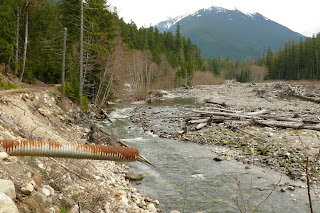
At 20.8 we came to the sidehill cut that was expanded over the years until all work ceased last year when the gate was locked down below. This is a very unstable slope of fine-grained silts that will open up into a yawning gap if full-scale road rebuilding by further cut-and-fill is allowed to commence. As it is, with minimal work and use of properly-sized equipment, the causeway a short ways ahead across the mouth of Downey Creek can be extracted, then this section of road can be closed to vehicle traffic to avoid having to continue to cut and fill here to maintain a functioning roadway. The river channel runs right alongside this point now, guaranteed to ensure future washouts:
20.8, just before Downey Creek

And finally, the Downey Creek damage was before us. This spot will really benefit from having the causeway removed, and a foot/equestrian bridge to replace it will cost a tiny fraction of what it would cost to install a set of vehicle bridge spans. With a tiny fraction of the impact to the general area as well of course. This is where most of the threatened Chinook salmon spawn, since Downey runs clear while the main stem Suiattle, coming off the glaciers and volcanic ash-laden slopes of Glacier Peak and its "great fill" runs silty. The short foot/equestrian bridge installed here to cross the gap from causeway to bridge is a good example of what could be built to replace the entire causeway. The pier(s) required for a foot bridge would be a small fraction of the size of those required for a road bridge, and it's the piers that matter to the alluvial fan.

The bridge over Sulfur Creek has a big gap at the down-valley end, temporarily bridged for feet, bikes and horses. We made it to the old trailhead and a short ways beyond, and saw on the first mile of the Suiattle Trail what the current road beyond Green Mountain turnoff could look like with a few more decades behind it. That very pleasant and easy first mile would then be extended to an easy and pleasant 5 miles of former road, from Green Mtn to Milk Creek, narrowed down to trail. It just makes sense.
The first mile of the old Suiattle trail, once a road that went as far as Milk Creek. Envision this being the condition from Green Mountain turnoff on. Or at least from just before 20.8. This is such a pleasant trail for all ages, something we need more of. The easy way to get it is to close the road before Downey Creek, as per Alt C.
Finally, just a few yards from the gate I paused when I heard a familiar chirp. Up above me was a woodpecker, tapping away. I realized had I been in a car, there was no way I'd have heard or seen this guy. And had cars been roaring by, no way would this guy have hung around anyway. There are many subtle but significant benefits to road closures.

Friday, April 13, 2012

Introducing Cascade Catalyst - coming to members' email inboxes soon!

N3C Members - watch your email inbox for your issue of Cascades Catalyst, our new member e-newsletter. You'll get a copy if you provided us with your email address when you became a member or when you renewed. If you're a member and have an email address but don't get your copy, perhaps we don't have your address, or it's changed. Either way, email us at catalyst@northcascades.org and let us know and we'll update your email address and send you a copy of the current issue!

If you're not a member, you should join! Go here: http://www.northcascades.org/signup.html


Friday, March 30, 2012

John S. Edwards, N3C board member, passes away

We regret to inform you that John S. Edwards, long term board member of NCCC has passed away. 


Click here to view a memorial with photos and biography. He will be sorely missed by his cohorts and friends.