Sunday, April 28, 2013

Snow report, April 27, 2013--N. Fork Cascade River


It's been too long since I've done a snow report, so here it is.  Based on  my ski experience this winter, and especially my last trip to the S. Fork Stillaguamish valley on March 22, I thought this was a great snow year because the Big Four picnic area was still under about a meter of snow.  At that time, I shared my thoughts with Mauri Pelto, who was quick to point out the SnoTel data from Lyman Lake was rather average, with a snow water equivalent of about 55 inches.
I decided to travel farther afield this time, to see how the snowpack looks in the N. Fork Cascade River and to enjoy some avalanches.
I was disappointed to find that the snowpack less than average, with only patchy snow and mostly bare road all the way to Midas Creek.  Only just below the Boston Basin trailhead does the snow get consistently over a half-meter.  It is evident that the S. Fork Stilly received way more snow at low elevations than did the Cascade River system.  This is something of a mystery, considering the peaks that surround the Cascade are basically 2,000 to 3,000 feet higher than those above the Stilly.  I attribute it to the orientation of the valley, and its proximity to the ocean--the Stilly resides in the Puget Sound convergence zone, with no other mountains to intercept the moisture.  The Cascade is "downstream" from the Stilly and thus doesn't receive as much moisture.


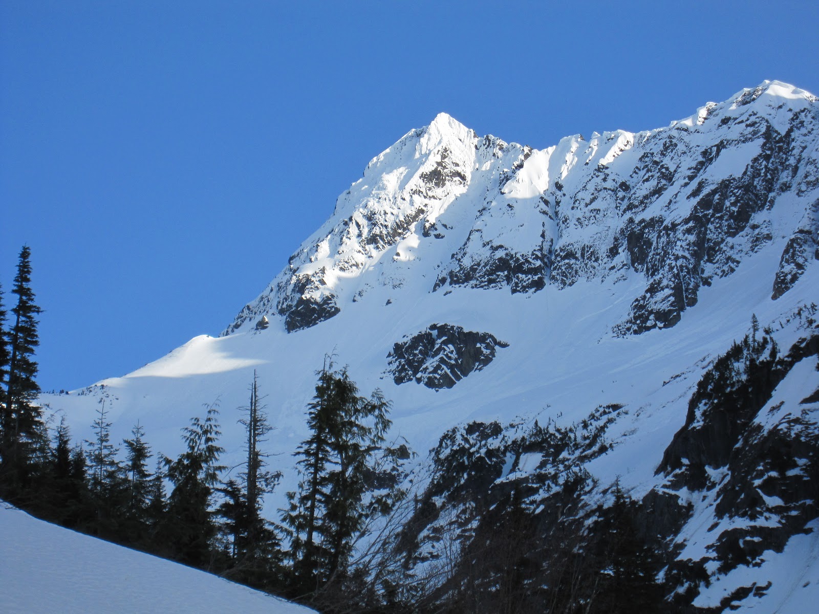
As you can see, the upper reaches of the North Cascades appear to have a healthy snowpack, but in reality it is appearing to be an average year, despite a cool Spring (The National Weather Service noted that the streak of days in Seattle below 70 F ended this past week at 197 days--the longest streak is 228 days from Sept 29th to May 13th, 2000).

Still, the skiing was just great, with the warm temps softening the snow perfectly such that I was whooshing along until well after sunset.  I should note that I was alone up there--the ski tracks you see were made by me.  A party of three was up on Eldorado, and a party of four skiers was in Boston Basin, but I had the valley to myself.  Oh darn!


Only a handful of respectable avalanches, certainly no big ones despite three days of 70 degree weather and snow level above 9,000 feet.  The weather turned, but not until I was drivinig home--yay!  Needless to say, I'll be back up next weekend if the weather is good...

Saturday, April 20, 2013

Bus service between Lucerne on Lake Chelan and Holden Village will operate weekends only, beginning May 1st

As the Holden Mine remediation work begins in earnest this summer, transportation that in past years ran all week up Railroad Creek road from Lake Chelan to Holden Village will only be available on weekends. This would effect your plans if you intended to go in to the Glacier Peak Wilderness from the east, up Railroad Creek to Hart or Lyman Lakes, and from there to Spider Gap or Cloudy Pass, or beyond to Image Lake during this the final summer with a shortened Suiattle River Road. Also you will not be able to stay as a guest at Holden Village this summer or next, since all guests are volunteer workers during that time and the rest of the rooms are occupied by remediation workers. There's a nice campsite just west of the Village that remains open, however.

For background on the Holden Mine remediation, see the current issue of NCCC's journal The Wild Cascades, at http://www.northcascades.org/magazine.html. NCCC has been following the environmental issues behind this project for some time, and you can find stories on the remediation in these back issues: Winter 2012, Summer/Fall 2011, Spring 2010, and Spring 2009.

Lake Chelan bus access restricted beginning May 1 between Lucerne, Holden

http://blog.oregonlive.com/terryrichard/2013/02/lake_chelan_bus_access_restric.html
on February 01, 2013 at 3:00 PM, updated February 28, 2013 at 7:41 AM
 
Hikers need to plan ahead this summer if they plan to use the bus shuttle between Lucerne and Holden on Lake Chelan in Washington.
The Okanogan-Wenatchee National Forest says the bus will operate weekends only, beginning May 1.
The bus transportation, operated by the Lutheran community in Holden Village between Lucerne (on Lake Chelan) and Holden, will only operate on Saturdays and Sundays in coordination with the Lady of the Lake boat schedule.
The reduction in the number of bus trips between Lucerne and Holden is a result of increased Holden Mine remediation activities starting this spring.

Holden Mine is an inactive mine located on the Okanogan-Wenatchee National Forest about 50 miles north of the city of Chelan and 12 miles west of Lake Chelan along Railroad Creek.
The Railroad Creek valley offers access to the Glacier Peak Wilderness from the Lake Chelan area and therefore these recent changes affect access to the wilderness area. Remediation (or clean-up) of the Holden Mine is a combined effort of the U.S. Forest Service, Intalco Corporation, U.S. Environmental Protection Agency, Washington Department of Ecology and Holden Village.
It is the largest remediation project on Forest Service lands in the United States. This spring will mark the first of several heavy construction seasons as part of the implementation phase of the Holden Mine clean-up project.

The popular Glacier Peak Wilderness trail systems, Hart Lake/Lyman Lake Trail No. 1256 and the Pacific Crest Trail No. 2000 will remain open and accessible for through-hikers throughout the implementation phase of the project. A re-route has been constructed for hikers to use between the Holden Village bus drop-off area and the Hart Lake/Lyman Lake Trailhead around the clean-up operations.

Additionally, Holden Village will not be accepting guest reservations between May 1 and Nov. 27 due to the heavy construction in and around the village anticipated this field season.
Hikers will not be able to stay overnight at Holden Village.
The Forest Service campground, located less than a mile west of Holden Village at the entrance to the Glacier Peak Wilderness area, will remain open throughout the remediation activities.
Hikers that had planned to stay at Holden Village as part of a trip into Glacier Peak Wilderness Area can consider camping at the Forest Service campground in order to comply with the Saturday/Sunday bus schedule. Camping is not permitted on the leased grounds around Holden or on Holden Village private property. Holden operates under a special use permit with the Okanogan-Wenatchee National Forest.

As a public safety measure during remediation activities, several temporary trail closures have occurred in the Railroad Creek Valley over the last few years. As a result, it is not possible to hike between Lucerne and Holden Village during remediation activities. Hikers must utilize the Holden Village bus transportation on Saturdays and Sundays to access the Hart Lake/Lyman Lake Trailhead and Lucerne.

The following trails and surrounding areas near Holden Village are closed until the implementation phase of the project is complete.

- Lower Railroad Creek Trail No. 1240 is closed from Wilson Creek to the mine tailings located between the 8 and 9 mile points. This means it is not possible to hike to or from Holden Village on this trail while this closure is in effect.
- Goat Trail No. 1245.1 is closed
- Tailings Bypass Trail No. 1240.3 is closed
- Copper Falls Trail No. 1246.1 is closed from Goat Trail intersection for one mile south
- Copper Creek Trail No. 1240.21 is closed
- Miners Interpretive Trail No. 1245 is closed
- Monkey Bear Falls No. 1256 is closed

For information or assistance in planning a trip to the Glacier Peak Wilderness Area via Holden, please contact the Chelan Ranger District at 509-682-4900 for the latest updates on trail closures, re-routes and/or transportation to wilderness trailheads.

For more information about the Holden Mine Remediation Project visit the Okanogan-Wenatchee National Forest website at www.fs.usda.gov/okawen/.

For information about the Holden Village operations and transportation visit the Holden Village website at www.holdenvillage.org.
-- Terry Richard
©  OregonLive.com. All rights reserved.

Tuesday, March 19, 2013

The Wild Cascades magazine, Winter 2012, now online!

Enjoy the new issue of The Wild Cascades on our newly re-designed web page for our journal, at:

http://www.northcascades.org/magazine.html

Contents:

-NCCC board member Thom Schroeder
-New FS appeal process proposed
-Proposed motocross project on the Mountain Loop Highway
-Hopes for a new Alpine Lakes bill
-New NOCA Superintendent, Karen Taylor-Goodrich
-Suiattle River Road EA decision
-Farewell to Chip Jenkins
-Chip Jenkins looks back
-Mine remediations
-Corvid’s eye
-Reiter update
-Sustainable national forest roads
- Yakima Plan blunders on
- North Cascades Glacier Climate Project field report 2012
- Cascade rambles: A day in the clay

Sunday, March 10, 2013

PALMER "Chip" Jenkins--An apology from the Editorial Committee


On behalf of the Board of Directors of the North Cascades Conservation Council, and specifically the Editorial Committee, I'd like to offer our most sincere apology to Chip Jenkins for getting his name wrong in the recently released edition of The Wild Cascades (Winter, 2013).  We strive to get the facts straight in all we do, and this is one we feel especially bad about, considering what a great person and leader Chip is.

Saturday, March 2, 2013

Snow Report March 1, 2013


I normally avoid skiing when it rains, but in this case, I wanted to assess the snowpack after the big Pineapple Express (atmospheric river) rolled through Thursday-Friday. Besides, the NWS issued special avalanche warnings, so that sealed it for me! Warm temps and sub-tropical moisture were still in evidence as I made my way out to Big 4--a delightful ski despite the moderate rain falling. The ski conditions were actually great--a nice fast track that provided perfect kick-and-glide throughout the day.

With the snow level at about 6,000 feet, I was concerned that the warm rain would significantly erode the snowpack, and percolate down to strata that would cause "premature" removal down to climax levels. To my surprise, another couple of feet of snow has fallen in the past 10 days, so instead of a smaller snowpack, it was actually much deeper than last week, even down in the valley. This new snow effectively absorbed all of the rain, and also presented a nice stratification layer that protected the base snowpack, with expected avalanches sweeping off only the top
layer(s) of snow.
That's not to say there were no big avalanches. On the contrary, Big 4 had four major events in the three hours I was there. Even from more than a mile away, the sound was impressive, the roar filling the valley. I took the trail to Big 4 to film some of the action, but as I reached the edge of the forest, it became very clear that this was too close, and I was in the danger zone. Fresh avalanche debris was only about 50 meters distant! There is now more than 1.5 meters of snow on the ground at the picnic area at Big 4 (1,800' elevation). Check out these pics:


The tip of my ski pole is on the surface of the picnic table, and is 1.4 meters long.


This is from the edge of the woods. All my little hairs were on end--my senses demanding I leave NOW. The waterfalls were glorious.


It was great to see the Stilly at flood. It was really blazing, but was not up in the woods. The rip-rap bank armoring that supports the hiking bridge was not being hammered too bad. It was spooky crossing the bridges, as the snowpack was at the top level of the railings, meaning any slip, misstep or cave-in of the snow would be a bad thing.

The snowpack is doing great. Happy fish, happy farmers, and happy glaciers. A couple of weeks until the Equinox. Sure hope we pile on many more layers before the season turns and the melt-down starts. Oh, can't wait to get out to Cascade River and watch the BIG avalanches...

Thursday, February 28, 2013

Wild Cascades winter 12/13 now in the mail to members!

The latest issue of The Wild Cascades will be arriving in NCCC members' mailboxes soon!

Articles in this issue include:
-New FS appeal process proposed
-Hopes for a new Alpine Lakes bill
-New NOCA Superintendent, Karen Taylor-Goodrich
-Suiattle River Road EA decision
-Farewell to Chip Jenkins
-Chip Jenkins looks back
-Mine remediations: What’s so unusual about the unusal?
-The Corvid’s Eye
-Reiter update

-Sustainable national forest roads
-Yakima Plan blunders on

-North Cascades Glacier Climate Project field report 2012
-Cascade rambles: A day in the clay


You can receive each copy of TWC as soon as it's released by joining NCCC. CLICK HERE to join us!


Monday, February 4, 2013

Inslee’s First Request Bill Raises Concerns

News Release
February 1, 2013

Inslee’s First Request Bill Raises Concerns

Battles loom over controversial $5 Billion Yakima Water Plan

Contact:
  1. •Chris Maykut (President, Friends of Bumping Lake) chris@friendsofbumpinglake.org   206.818-9778
  2. •Brock Evans (President, Endangered Species Coalition) bevans_esc2004@yahoo.com 202.425-1517
  3. •Karl Forsgaard (President, North Cascades Conservation Council karlforsgaard@comcast.net  206.330-8966
  4. •Rick McGuire (President, Alpine Lakes Protection Society) rckmcguire@gmail.com  206.363-6954

Today conservationists expressed deep disappointment and anger regarding newly inaugurated Governor Jay Inslee’s first act as governor.  On Tuesday, Governor Inslee announced the submission of his first request bill to the legislature, a funding request for the Yakima Basin Integrated Water Management Plan (Yakima Plan).  The plan promises such benefits as temporary jobs, irrigation security, environmental restoration, and increased fish runs.  However, many local, state-wide, and national conservation groups have opposed elements of the Yakima Plan as it is written because of two highly controversial elements: the construction of two massive dams and the designation of treasured National Forest lands as National Recreation Areas for off-road vehicles.
“We are incredibly disappointed with Governor Inslee’s quick support of the Yakima Plan, particularly in light of the ongoing opposition that has been expressed by a growing number of conservation organizations,” said Chris Maykut, President of Friends of Bumping Lake.  “There is so much good that can come of the political attention being directed to the Yakima Valley right now, but spending $5 billion dollars and destroying ancient forests, critical habitat for endangered species, and beloved recreational areas is not worth what we as Washingtonians get out of the deal.” 
Two massive irrigation dams are at the center of the Yakima Plan. One of them, at Bumping Lake adjacent to the William O. Douglas Wilderness, would inundate and destroy a popular new National Forest campground, a thousand acres of ancient forest, 15 historic cabins, trails, and access roads to popular hiking spots.  In October 2011, the Alpine Lakes Protection Society, California Water Impact Network, Endangered Species Coalition, Federation of Western Outdoor Clubs, North Cascades Conservation Council, Washington State Chapter of the Sierra Club, Western Lands Project, and Western Watersheds Project sent a letter to the Washington Congressional delegation opposing a new Bumping Lake dam.

In 2008, the Bureau of Reclamation studied the other project, Wymer Dam, north of Yakima, and found that it had a taxpayer benefit-cost ration of 31 cents of positive economic impact for every dollar that would be spent on it.
The Yakima Plan’s current proposal for two new National Recreation Areas within the Okanogan-Wenatchee National Forest with 40,000 acres for off-road vehicle use is also meeting with stiff opposition within the conservation community.  Twenty-nine organizations signed letters in March 2012 regarding the proposed National Recreation Area designation, which poses numerous threats to the ecosystem, watersheds, and non-motorized recreational opportunities.  Despite numerous roundtable meetings throughout the fall and winter in the community about the NRAs, none of these 29 organizations has become supporters of the Yakima Plan.
“At a time when we as a state and a nation continue to struggle to fund basic social programs, keep state parks open, and redefine what our financial priorities are as a society, why would we support spending billions from our state economy on wasteful water projects?” said Maykut.  “Many if not all of the goals of the Yakima Plan can be achieved through legislation, mandatory conservation and water marketing, and using a thoughtful approach when it comes to the important issues that Yakima irrigators face.  As we saw with the Elwha Dam removal last year, the era of dam-building and ecosystem destruction should be over.”
Links: