It's been far too long since my last post, and that's because it's been far too long since my last trip to the mountains. Indeed, this is the first time in 30 years I did not make a significant trip/climb in June. Weather has been an issue, but finally we got some of the good stuff. I'm way out of shape, but still managed to pull together a trip highlighting areas in the American Alps Legacy Project .
This write up will likely run as an article in the upcoming The Wild Cascades, so consider this a free sneak preview. Enjoy the link to the photos below!
-Tom
On the Outside Looking In
July 4 – 6, 2012
My mountaineering focus has changed over the past several years, in part due to injuries and evolving life priorities, and more so because of my involvement with conservation efforts on behalf of the North Cascades Conservation Council and the American Alps Legacy Project. I have made it a goal to visit lands outside federal recognition as National Park (Dept of Interior) or USFS Wilderness (Dept of Agriculture) designation. Usually this means lower elevation mountains, places without a marquee name (though there are large exceptions in the form of the Methow Mountains, Black Peak and others) but which provide critical habitat and are important and impressive in their own right. Over the past several months, I’ve been studying maps, trying to find a place as representative as any of the seemingly arbitrary placement of the National Park boundary, the boundary of the Pasayten Wilderness and the vast stretches of mountains and valleys between which remain inexplicably unprotected. I found such a place along Highway 20 in the Granite Creek trench, a place with no trail leading to it, no trailhead, some un-named 7,000 crags, and plenty of opportunity to learn more about the landscape.
One thing I know, and keep relearning, is that mountains, even small ones, are much bigger than we think they are, and much bigger than we are. After a classic North Cascades approach from the old school handbook of mountaineering and route finding, I found myself atop a crag, surrounded on all sides by magnificent forests, soaring peaks, tumbling glaciers and cascading waters. Yet I was on the Outside Looking In.
I’ve said it before, and I’ll say it again--It was with a bit of trepidation as I left my car along Highway 20, not only because I was confronted with trackless forest and many unknowns rising above me, but out of concern it might not be there when I returned (I had cleared it with the WSP, but along a heavily traveled road during a holiday week, one is exposed to more than the usual attention, especially a rig by itself “in the middle of nowhere.”)
The ascent was generally three equal parts, the first through a recent burn (not bad, most trees small diameter Ponderosa and Lodgepole pine), then lovely moss forest; the second through and up a steep, green hell of brush; and the third a spectacular ridge ascent on snow to a steep summit pitch. I should note I dubbed the steep brush “The Green Mastication”, for it certainly filleted me and left me bloody and generally shredded. Ahh, going trail-less in the North Cascades! At points on both ascent and decent, I was literally swinging from tree to tree, brachiating like the alpine hominid I am. Unlike other monkeys, I had 50 pounds on my back—an exercise in energy management, if you will. All the while keeping on a route that was as much dead-reckoning as it was following game paths. By the way, I don’t flag routes—it makes it more fun on the way down/out!
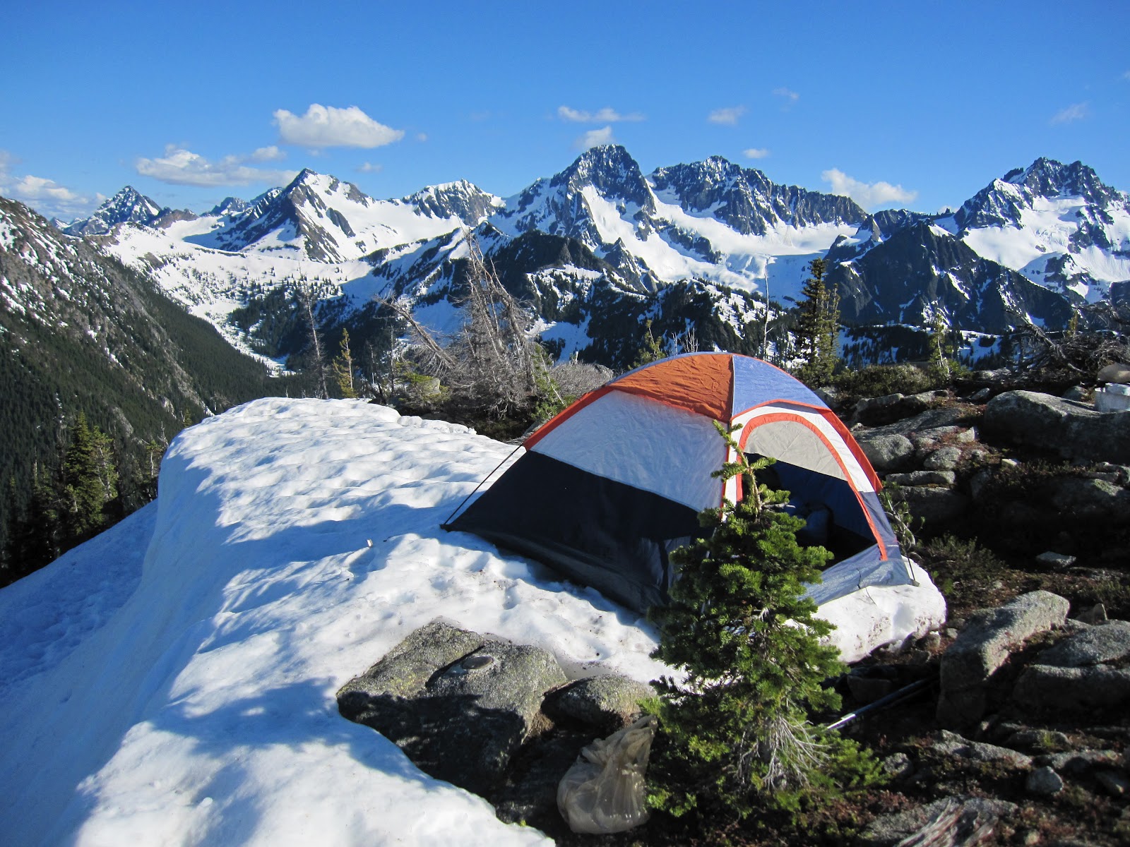
At the summit, I found a tiny, postage stamp of a flat spot on a quickly diminishing cornice. I was very fortunate that cornice lasted the 50 hours I was there (two cycles of the sun)—by the time I left, one corner of the tent was literally hanging off the edge of the cornice. Not really dangerous, but it left little room if there was an encounter with larger wildlife (though almost had two serious accidents with deer jumping in the highway on the drive home). It was a great camp—few bugs and when they showed up, so did a nice breeze. I had planned to climb an adjacent 7,200’ peak, but as this is the first time in 30 years I did not climb in the month of June (weather issues), I was and am too out of shape. I chose to stay at camp, as this facilitated the primary mission objective: record and compare/contrast areas that are unprotected, proximate and adjacent to areas that are. As evidenced by the accompanying photo gallery, I think the camp served as a delightful platform from which to perform my research.
I’ll let the pics tell the story, but will note the Kimtah Glacier is spectacular! Indeed, the entire northern façade of Ragged Ridge is world class alpine material: big icefalls, cirque glaciers cradled by jagged spires, tremendous relief and big forests. A full moon rising over the Methow Mountains each night was remarkable, The Methow Mountains, the forests of the Granite Creek valley, with the obvious transition from wet west marine climate to dry east continental climate literally under my feet was awesome.

The whole area, even the adjacent small mountains and forested valleys had me wondering how so many mountains can fit in such a tight array. It also had me wondering about boundaries and borders.

The whole area, even the adjacent small mountains and forested valleys had me wondering how so many mountains can fit in such a tight array. It also had me wondering about boundaries and borders.
So how is it that I was on the outside looking in? Is it because the mountains are too low to qualify for recognition? Places such as cabinet Creek are amazing, productive and provide critical habitat for everything in the region, including us. The water pouring off our North Cascades literally power our lives, and provide food and clean water. The fact such vast areas remain unprotected does require attention—why aren’t they protected, and how can we get them protected? For these places are certainly worthy of recognition, and their best value is in keeping them pristine. For us now, and for generations to come.
Photo Gallery:
You might note I haven’t named the peak I was on—can you?

No comments:
Post a Comment