Sunday, June 19, 2011

Cascade River visits, 2011


I figured I should put a wrap on this year's visits to N. Fork Cascade River. Per earlier entries/reports, we made three visits to the valley this year, the final visit on June 3-4.
The main reasons we go at this time of year are because the road is closed (gasp, we access a place that is "inaccessible" due to the road being closed/snowcovered), and of course to watch avalanches.

Curiously, we didn't see much in the way of big avalanches this year, nor were they as numerous as in past years, especially considering the healthy snowpack. This is attributable to timing, as well as a generally stable snowpack. I should note we did see the remains of "Mr. Big" on the June 3 visit. Per the below photo, a huge slab, stretching from nearly the Triplets to Cascade Peak, and two or three meters thick let go, roaring in to the lower valley, and down to the confluence of Soldier Boy Creek!


(look closely--see the "white line" that rises from the sunny patch and extends left (East)? Below the line is much newly exposed rock, and above is generally still snow other than those rock islands. That's called a "climax avalanche" because it went right down to the bedrock. In the next picture, you see that snow filling the valley--some of the blocks are as big as trucks)


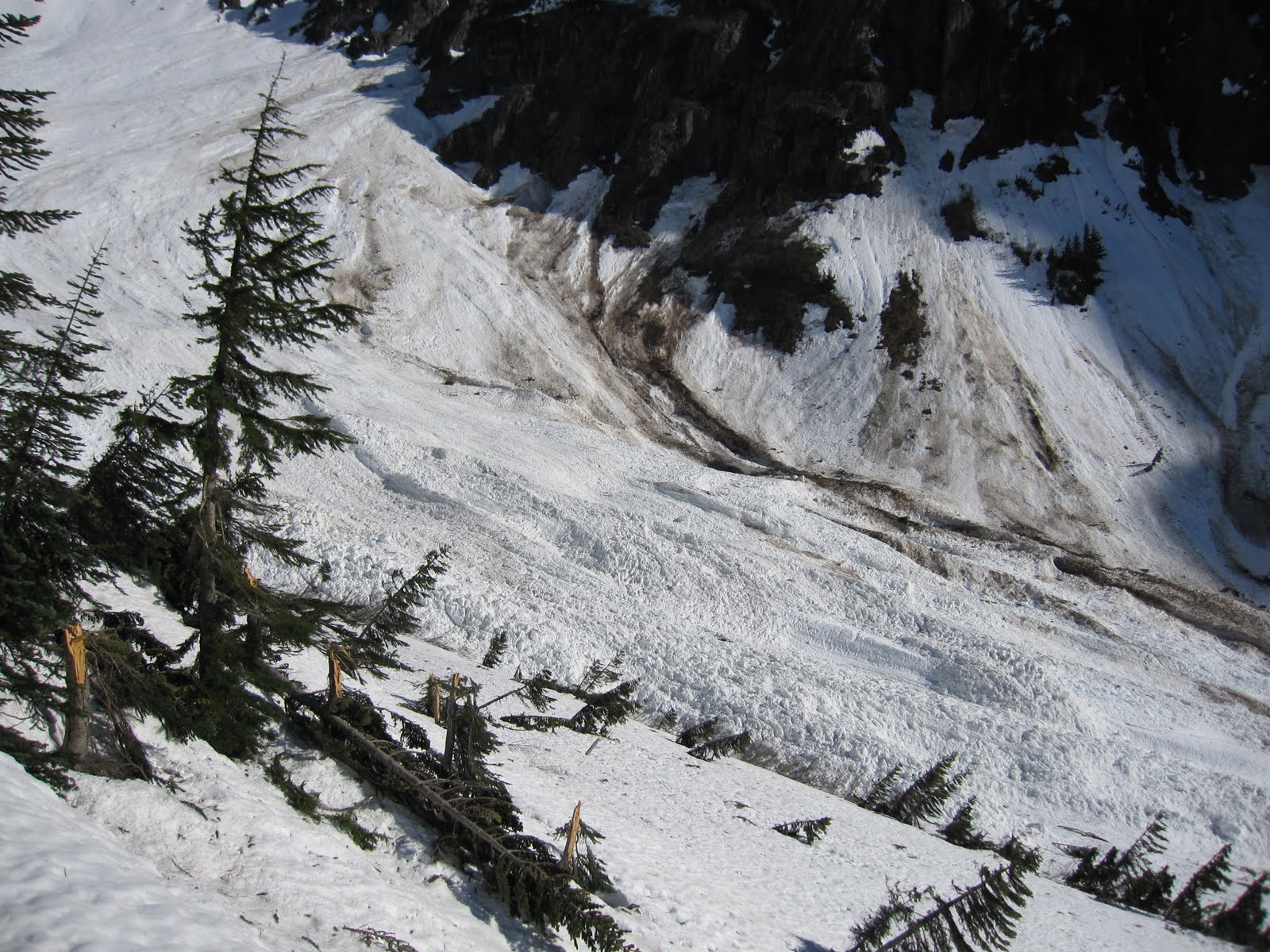
Oh, those snapped trees are not from avalanche(s)--they are from incredible winds. I should point out we saw more blow down this year than we have in three decades of visits. Must have been one hell of a wind-storm during the winter...
As well, see the streaks of dark material. Avalanches aren't just snow--they usually entrain tons of boulders, trees and rock, as was the case with this "Mr. Big".

And of course the crescent moon setting over J-burg (should be renamed Cascade Mountain) was spectacular...


So glad the road is closed in the Spring--this is a place of remarkable beauty and relief, It is a blessing to be able to hike/ski it and experience it as Wilderness. It's just not the same with cars chugging up and down.

Sunday, June 12, 2011

Bike-hike combo at Monte Cristo -- let's make more of these!

My family and I drove our pickup camper to the end of the Monte Cristo road back in the early 70s, "because it was there." That's what roads do, they make you want to drive them. I don't remember much of the journey, other than how the road was pretty nasty and narrow in places and it was tough when you met another vehicle going the other way. It seemed to attract a lot of others in cars, though, as I recall, many of whom didn't venture far beyond their cars.
Today, the Monte Cristo road is washed out so badly at the 1 mile mark from floods years ago, it was decided it would be silly to consider rebuilding it, and it's gated back where it branches off the Mountain Loop Highway at Barlow Pass now, where there's a parking area. When I first noticed that, I was thinking how I couldn't get up there anymore, with that closed road. Then I had and idea -- ride a bike to my favorite hike!

Now I love taking my mountain bike up there, riding the first easy mile, carrying my bike over the river ford, then biking up the old road to the end at the old mining town, locking my bike to a tree and hiking up to Glacier Basin.

On the way back out, I look forward to the ride down from the road end almost as much as I look forward to the spectacular scenery throughout the whole trip! Great fun, highly recommended, and quite popular. Be nice if some of the other rickety old roads around here, built for extraction of minerals and timber, were closed permanently below the big washouts and converted to bike-to-the-trailhead destinations. The Suiattle and Whitechuck would be ideal!

The advantages of this, over rebuilding the road, are numerous:
-Far less public expense
-Far less environmental impact
-Fewer vehicle miles driven = less oil consumed, less carbon emitted, more healthy population
-IT'S FUN!!

And I'll tell ya -- when I get too old for strenuous hikes, I'm going to hope there are more places like this to stroll alongside a beautiful river with views of high peaks. Old roads are great for less able hikers, especially after a few years of "greening up" so they look a little more natural.
So before you complain about a "lack of access" with your car to the end of every road in the mountains, think about getting there a different way, a way that might do you, and the world, some good!

Saturday, June 11, 2011

Suiattle followup

Thanks to all who have taken the time to comment (well, at least those of you with civility and some sense of a shared reality). I certainly don't treat the blog with as much scrutiny as I do my articles for publication, but I do feel the need to address a couple of points.
Okay, I get it, we didn't WIN the lawsuit, the USFS walked away from the project. In every field of competition I've entered, when a team walks off the field during the game, it's called forfeit.
In such cases, the other team is credited with a win, as in W.

I said a preferred alternative would be to end the road "just before Downey". Allow me to clarify--to me that means a mile or two before Downey, not AT Downey.

I don't remember any of the commentors being with Kevin and I when we walked the proposed job site with the USFS in (2005?). It was a cordial, professional meeting, and I respect the foresters in Darrington, and indeed, across the state. We were disappointed when many of the items we discussed did not come to pass with this project (like a narrow single-lane road prism through the repair corridor, or ending the road around Green Mtn turnoff, and NO rip rap and bank armoring!).

What's all of this about lack of access? I'll say it again and again: access is still there! Ride a bike--I've done it with a full pack and it's not that bad. Or enjoy a lovely extra hour of lush valley hiking. There's a reason these roads keep failing, and throwing money at it doesn't work except to waste money year after year. The USFS actually had heavy equipment stranded above the MP12-14 washout in 2006 when those floods hit--they/we can't repair this stuff fast enough. Look no further than Tenas Creek for the same story. The $850,000 per mile may be "Federal Highway monies", but that means OUR money. All the hew and cry to cut the budget should apply here as equally as anywhere else...

Oh, and access for the infirmed and elderly? valley hikes along the spectacular Suiattle sound like just the ticket. I should know, my right foot was torn off 10 years ago. Should we build a tram so I can accomplish one of my life goals to stand at the summit of Shuksan?
Through life we go through changes, and we get old, and suffer accidents, and inevitably slow down. That's how it works.

Tuesday, June 7, 2011

Suiattle River road--the real story

[NOTE: this area is not under consideration for inclusion in North Cascades National Park/not a part of American Alps. However, I feel compelled to address this since NCCC is deeply involved with many issues across the North Cascades, and there are those who would speak out about American Alps in conjunction with Suiattle (it's called conflation, but we're not above mucking it up to clear the air.]
We won our lawsuit against the USFS over the Suiattle River road rebuild. The USFS recognized they had stepped well outside the law on this one. Back to the drawing board, and as we have since 2003 (or is that 1953?), we don't just complain and sue, we offer reasonable, practical, affordable solutions to the situation (many NCCC board members want the road fixed at MP12-14).
There are those who contend we're trying to "lock people out of the mountains"--nothing could be farther from the truth. By encouraging lawful actions and supportable land-use plans by the USFS, and increasing land area recognized as National Park, we're trying to bring the Park to the people, and make back-country experiences possible for people now, and for generations to come.


Opponents point to NCCC participation in a lawsuit to stop repair work on the Suiattle River road (FS #26). We engaged in this legal action not because we want to keep people out, but because the USFS violated both the letter of the law, and the intent of the law by declaring the work did not need to be reviewed for environmental impact. They used a summary-execution rule called "Categorical Exclusion" to push ahead a project that was clearly beyond the purview of a CE.
See for yourself: https://picasaweb.google.com/kgeraght/SuiattleRiverRoad?feat=email#


In reality, several of the NCCC board members, including me, want to see the road re-opened to just before Downey Creek. We just want it done legally, and with minimum impact to taxpayers and to maximize the ecological health of the area. One can argue the wisdom of using TWO MILLION DOLLARS of Federal Emergency Highway monies to repair two miles of gravel road that's been out for several years (not an emergency, not a highway...), especially in this economy, but after looking at the pictures below, and the linked web-photo album, it is hard to argue the impacts on the land.

We measured the width of the recently cut swath at MP 14.4. It is between 100 and 120 feet wide, and 900 feet long. The original NEPA for this promised that "approxima​tely a half acre" of forest would be logged here. This implies a swath width of ~24 feet, instead of the 120 feet we ended up with. Rather than a half-acre it is over two.

End the road before Downey Creek. Have Sulphur Campground be the premier deep valley experience--a real family-hike-in campground within an hour's hike of the trailhead. Flat, scenic and a chance to experience natural vistas and soundscapes.

For those who contend that closing a couple of miles of road "prevents access". Just take a moment to consider what we're trying to access. The idea behind going to these places is to engage in hiking, walking, and experiencing the outdoors, not to drive an automobile.

Wildlife encounters like the photo below (taken on the Suiattle road) do not and cannot happen from an automobile.


https://picasaweb.google.com/kgeraght/SuiattleRiverRoad?feat=email#