Tuesday, December 29, 2009

Have your say on the state's plans for Reiter Foothills

Everett Herald - Monday, December 28, 2009
Restoration and trail-building work around Gold Bar has some people concerned
By Debra Smith
Herald Writer

GOLD BAR — State officials want to hear from you about restoration work and trail building in Reiter foothills.

The Department of Natural Resources plans a workshop for the public at 6 p.m. Jan. 13 at Monroe High School, 17001 Tester Road.

Officials are in the final stages of bringing some order to the 10,000-acre forest. For decades, outdoor enthusiasts have come from near and far to use thousands of forested acres stretching from Sultan to Index.

The area was shut down in November so officials could begin to repair damage and rework the trails.

Officials plan to separate Reiter into areas for motorized vehicles, horses, mountain bikes and hikers. They also want to establish designated trails and eventually build restrooms, trailheads and campgrounds.

The plan hasn’t been an easy sell to some longtime users, who are worried about less access. Officials are concerned about damage to the land, including salmon- bearing streams.

For more information about the meeting, contact Candace Johnson at 360-854-2803 or e-mail candace. johnson@dnr.wa.gov.


Sunday, December 27, 2009

WTA Feature on Cougar Mtn. credits N3C lifetime member Harvey Manning

Washington Trails Magazine, a publication of the Washington Trails Association (WTA) has a great feature in the current Jan/Feb 2010 issue about hiking in Cougar Mountain's historic mining district they titled Hike in History: Hitting the Mother Lode at Cougar Mountain. Read the full article HERE.

Harvey Manning (1925-2006), N3C lifetime member and legendary hiker/author, is credited by WTA writer Abby Wolfe as the conservationist who saved the Cougar Mountain area from encroaching suburbia:
Conservation activist and guidebook author Harvey Manning recognized Cougar Mountain's natural and historic value. Thanks largely to Manning's efforts, Cougar Mountain Regional Wildland Park was created in 1985, permanently preserving its rich heritage. Surrounded by Bellevue, Issaquah and Newcastle, it is the largest urban wildland in the US and the crown jewel in the King County Parks system.
WTA's website has a great short hike summary to go along with the magazine article. Note on the bottom of that page there's a link to a map so you can find the trail-heads and routes easily.

As the article says,
When winter shuts down hiking in the high country, I look to the Issaquah Alps for my inspiration.
It was N3C's Harvey Manning who gave them that name, and saved them for our enjoyment! To fully immerse yourself in Harvey's spirit, get a copy of "Irate Birdwatcher" on DVD, at the American Alps online store. You'll see why many of us revere him as the John Muir of the Cascades.

[And an insider tip: rumor has it that Washington Trails will feature articles about geology hikes in forthcoming 2010 issues. Experts will describe their favorite places to see spectacular North Cascades geology! Several of those hikes are likely to be in the American Alps study areas... stay tuned...]

Saturday, December 19, 2009

A Nurse Log in Downtown Seattle

We visited the Neukom Vivarium in the Olympic Sculpture Park downtown Seattle today. So should you!

From an interview with the artist, Mark Dion, on the PBS website:
ART:21:      "What does it mean to take a tree from its natural setting and place it in a gallery context?"

DION:     "I think that one of the important things about this work is that it’s really not an intensely positive, back-to-nature kind of experience. In some ways, this project is an abomination. We’re taking a tree that is an ecosystem—a dead tree, but a living system—and we are re-contextualizing it and taking it to another site. We’re putting it in a sort of Sleeping Beauty coffin, a greenhouse we’re building around it. And we’re pumping it up with a life support system—an incredibly complex system of air, humidity, water, and soil enhancement—to keep it going. All those things are substituting what nature does—emphasizing how, once that’s gone, it’s incredibly difficult, expensive, and technological to approximate that system—to take this tree and to build the next generation of forests on it. So this piece is in some way perverse. It shows that, despite all of our technology and money, when we destroy a natural system it’s virtually impossible to get it back. In a sense we’re building a failure."

This huge nurse log in the Vivarium downtown came from the Green River watershed, but it could be from any of the increasingly rare low-elevation ancient forests of the west side of the Cascades. A prime example is the Baker River valley upstream from the head of Baker Lake, adjacent to North Cascades National Park.

Ancient forest of the Baker River - real and intact now, but for how long? The American Alps Program seeks to bring this and other* intact ancient ecosystems into National Park protection. Because if it is lost, it will be impossible to get it back.
*Other ancient forest study areas of American Alps adjacent to NCNP include lower Thunder and Big Beaver Creeks and the Cascade River valley.

Thursday, December 17, 2009

Coming Soon: "North Cascades: People, Places, and Stories"

Mark your calendars! Thanks to the generous support of REI, KCTS 9 will be airing North Cascades: People, Places, and Stories this January. The Wilderness Society is very excited about this documentary all about the beautiful North Cascades. TWS is a sponsor and KCTS-9 community partner.

The documentary will broadcast on KCTS 9 / KYVE 47:
Sun, 1/17 at 10:30 p.m.
Wed, 1/20 at 7:00 p.m.
Sun, 1/31 at 4:30 p.m.

 Also, it will air in Spanish (ESP) on the V-Me network 1/23 at 7PM and 1/30 at 7:30PM.

Wednesday, December 16, 2009

New Photos posted to the AmAlps Gallery

More photos have been added to the American Alps Photo Galleries! This time it's some spectacular winter shots taken from near Cascade Pass. Here's a little taste:

On the Galleries page, look under "Area 2: Cascade River" for the new top listing: "Cascade River - various Spring trips in 2008 and 2009." Check out that bear and avalanche track!

And a little tech note from our web guru: some of our galleries  start in SLIDESHOW MODE. Nice big full-screen photos appear! But they change too fast! So... just click the PAUSE button right away (it's one with the 2 vertical bars) and take your time to soak-up the scene and read the caption, advancing the photos manually with the "right arrow." 

The Picasa photo site likes to start showing slides in 3-second rapid mode, which is too fast for our taste, and there doesn't seem to be a way to change how it behaves when it starts-up. You can slow it down by clicking the little (+) symbol below the photo, but we think it's best to just PAUSE it and use the "right arrow" when you're ready - no need to rush these spectacular pics! And just click the big "X" on the right to close the slideshow and see all the thumbnails, and choose any pic you want by clicking on it. Enjoy!

Trip Report: A First Ski Trip of the Winter!

A trip report came in that we had to share:
Just Barely Enough    -It has been a sparse winter in terms of snow, with the lower elevations of the Cascades snow-free thus far, save for a day of snow here or there that quickly melts away.  Despite frigid temps over the past couple of weeks, it has been dry (not unusual). But suddenly the forecast called for "snow overnight, with rain by afternoon." So I took my chances and headed up, carrying hiking boots just in case there wasn't enough snow.  I left late enough to allow the plows to clear any problems on the Mountain Loop, and sure enough, on my way out, passed the plow on it's way back in from Deer Creek. I was able to drive to Sunrise Mine road, where there was just barely enough snow to ski on!  I could have driven the road, but why drive what can be a scenic ski tour??  And scenic it was--dry, with the high peaks of the Stilly headwaters flirting with the clouds. (See pics.) The skiing was quite enjoyable--at times I was able to lock my ankles together and slalom with my 210cm XC skis. I feel cold air rushing in to my lungs, frosty wisps of exhalations, my heart working in rhythm with my legs, my whole being at one with the world around me. Then the clouds and rain came--I glanced at my watch:  12:15.  Quite a forecast--rain in the afternoon was spot on!  I continued skiing until about 1:30, when it really started coming down.  I headed out, the snow thinning under the deluge. It was just barely enough!
Stilly Headwaters                                                  Morning Star Peak 


Del Campo

Tuesday, December 15, 2009

AmAlps Conclave Praises Blog, Greets Supporters

At the meeting last night, key players in the American Alps Project met to map-out future strategy. Among the hot topics were THIS BLOG and the newly refurbished AmAlps main website! Phil says:
I had to take a bow and explain that it's really just as simple as writing an email to a group, but in this case the group is all of our supporters out there! (There seems to be some interest in a Facebook page... stay tuned...) And just so ya know -- the AmAlps site now features a web-based Field Guide and online Photo Gallery that focuses on the study areas, with new photo albums posted recently that play as nice big full-screen slideshows using Google's "Picasa." Here's a sample thumbnail from one of the new galleries, courtesy of Tom: 

You'll also get a kick out of some of the "retro" postcards from the 60s I put up on our "The Story" page!
And speaking of supporters, we had reps from several groups present who are now or will soon be fully signed-on members of the American Alps coalition! Of course Mountaineers and NPCA reps were present but a few new ones were, too, and we'll be announcing these new partnerships soon.

Also Jim Davis, N3C Executive Director, said more about the AmAlps economic impact study that's starting soon. (See our previous blog post about that.) A consultant has been hired and the study will be getting underway with the new year.

Anyone interested in forging new alliances our exploring the economic benefits of new Park in the North Cascades is encouraged to contact us at info@americanalps.org

Sunday, December 13, 2009

Upper Granite Creek trench

Okay, I'm going to try a new method of communication, the blog. Not that I haven't blogged before, but this is new for conveying the power and majesty of the North Cascades. I've been sending family and friends email "trip reports" of my travels since the inception of email. The trip reports started as a technical guide for me/climbing friends, along the lines of Fred Beckey or Harvey Manning, but with special footnotes about "stay in the creek-bed until through avalanche chutes filled with slide alder and devil's club". Over the decades, they've become less technical, and more lyrical, catching some of the effort and route, but more often the emotions generated by experiencing true wilderness. And as the many photos attest (see photo galleries at northcascades.org, or here at the americanalps page), the North Cascades are true Wilderness, especially where the US Congress has designated it so!
;-)

So, what of Granite Creek trench and this blog stuff? Well, over the years I've suffered falls, dodged avalanches, watched boulders zip by me on steep glaciers at 70mph (special shout out to NCGCP, 2005) and had bears wandering through camp, among various adventures. But by far the most scared I've ever been in the hills is when ol' sparky shows up. Yep, lightning has induced fear in me more than most anything. And it just happens that Granite Creek, and even more-so, the Methow Mountains, seem to be a magnet for T-storms. They usually crop up over the Methow (on the E) , and then drift down Granite Creek ( to the NW). On a solstice trip in the summer of 2005, I was camped close to Wing Lake. The weather was simply magnificent, and the forecast indicated more of same. On day two, as I ascended Black Peak, I could see high clouds streaming in from the SW (standard pattern for weather, but usually for rain and "expected" weather). No hint of convection al all, just high clouds. I kept a wary eye on the descent, and when one is at nearly 9k feet, one can see a long way out to sea, even from this NE location in the range. Still no convection.

Back at high camp, the weather was fair to clear far to the E, but darkening to the W. I should note the view S and W once down on the Wing Lake bench is limited by the hulk of Black Peak, and the high (crest) ridge linking to Corteo Peak. In short, I couldn't see what was coming, only that there was thankfully no convection over the usual lightning generators (the Methow Mountains closely E of me).

Was that the rumble of thunder I heard?? Couldn't be, the clouds were still high, and the Methow was "clear".

Within in an hour, Black Peak was engulfed in clouds, the temp dropped 25 degrees F, and there was cloud to cloud lightning roaring near and far! I wasn't too concerned, as the bench isn't nearly as exposed at the camp at Ragged Ridge, and it was all cloud to cloud lightning (up in the sky well above the peaks). Then a cell moved directly over the summit of Black, and descended thousands of feet in seconds! Suddenly boiling clouds were BELOW me. Now "cloud -to -cloud" offered little comfort since I was in clouds, with lighting rods (peaks, crags, trees, tent) all around. in a calculated move, I stayed OUT of the tent and huddled in my rain gear, taking in the show. I was NOT going to be shrink-wrapped in a tent on this fine summer day!
It was an incredible experience, and one I am thankful for. Of the many times I've been in electrical storms, this was perhaps the least fearful I've been because I was relatively safe, and experienced it with eyes wide open.

see all of this at

http://picasaweb.google.com/tphammond/BlackPeakSolstice2005#

(sorry to not get more storm shots, I was a bit, um, busy and with an old 35mm camera, didn't want to lose all of my film.)

Two hours later, as the sun went down, the storms went down.
I love the North Cascades.

Thursday, December 10, 2009

NCNP 101 - A History Lesson: Thunder DAM??

Just imagine... the canyon of Thunder Creek where it met the Skagit had already been drowned under the Diablo reservoir, creating "Thunder Arm" and forever silencing the namesake thunder of the creek. Then in the early 60s, City Light and others were actively planning to raise Ross Dam and further flood the upper Skagit valley, drowning Big Beaver's ancient forest (more on that in a future post).

AND plans were underway to build a new dam on Thunder Creek, just upstream of where it meets the Diablo reservoir, drowning Thunder's ancient forest! In fact, it wasn't just going to be submerged, it would have been logged before the dam was built! (Brilliant, eh? "Cut and sell the trees, then dam up the valley!" Where have we heard this one before?)

Note the original photo caption below refers to it as "1,500 acres of commercial timberland." (Click photo for enlarged view.) This was the same treatment given to the upper Skagit for Ross Dam/Lake: "Cut it down, dam it up!"


The artist's conception published in the Federal Study Report of 1965 (left) shows what this disaster would have looked like. Thanks to N3C, this project, as well as High Ross, were stopped in their tracks.
Photo issustration above: The North Cascades Study Report, 1965, USGPO

BUT - look at the map below... the blue color of the National Park at Thunder Creek today (circled) still has a big "dip" where Ross Lake NRA is shown in purple, going around this phantom reservoir (and all of Ruby Mountain, too*)! Why is that boundary bump still there today? Does it matter? Well, you bet it does: NRA is NOT the same as National Park, and the ancient forest of Thunder Creek deserves National Park protection now as much as it ever did!


(Click the maps above for a closer look.)
Lower map courtesy DeLorme TopoUSA

American Alps will bring permanent National Park protection to lower Thunder Creek's ancient forest. Join us!

*Ruby Mountain was to have had an aerial tramway built on it, in the original, more developed National Park plan.

Wednesday, December 9, 2009

Teanaway "bindergate" prompts Kittitas County to post content of missing binders

Due to public demand arising from “bindergate,” Kittitas County has posted the content of the missing binders on its website, showing AFLC’s  2007 applications to segregate the AFLC land into 20-, 40-, 80-acre lots etc. See


For background on this topic, see our previous post
On November 3, 2009, the Board of County Commissioners temporarily suspended the subarea planning process to complete an investigation into two binders that were returned from American Forest Land Company (AFLC). While the investigation has not been completed, the information contained in the binders is now available for public review.
AFLC Administrative Segregation Application Binders:
The next public meetings scheduled for December 16, 2009 is CANCELED.

Sunday, December 6, 2009

American Alps photos coming!

Hi Folks,
Be aware there'll be more action on this site now that Phil has shown me how to easily get photos and words on this space. Stay tuned for some photo galleries on areas of the American Alps proposal. I'm sure you'll be surprised and stunned to find many spectacular areas are not protected in any formal sense. I know the USFS folks administering areas in question take issue with the characterization the lands are "unprotected", but the fact is, administrative protections such as "Inventoried Roadless" can be swept away with the single stroke of a pen by an unaware president or some such, and then these same good people are compelled to dig mines, or build roads in places they don't really belong (see Azurite mine).
Lots more photos, keyed to a map of proposed additions to NCNP, are now available for viewing on the Photo Gallery page of the American Alps website!


Friday, December 4, 2009

Middle Fork NRCA designated

From our friends at Mountains to Sound Greenway:

New 10,273 acre conservation area links Mount Si to federal forests -- Commissioner of Public Lands Peter Goldmark designated the new Middle Fork Snoqualmie Natural Resources Conservation Area (NRCA). The river valley was identified as ecologically distinguished, featuring patches of natural-origin forests, important fish and wildlife habitat, and scenic views. This natural area, with 10,273 acres within its proposed boundary, is nested along Interstate 90, and flanked by the Mount Si NRCA and federal forests and offers wildlife corridors for many large and small animal species alike.


MTSG has more at http://www.mtsgreenway.org/newsandpublications/middle-fork-nrca

Thursday, December 3, 2009

URGENT! Send an email TODAY to save Washington State’s Reiter Forest!

Please take a minute to send an email TODAY to save Washington State’s Reiter Forest from off-road vehicle (ORV) damage. Reiter is located on the west side of the North Cascades north of US 2 near the town of Index (click here for a map).

We understand that ORV users are flooding the Washington State Dept. of Natural Resources (DNR) with email comments, and we need to counter that with emails from many individual non-motorized recreationists and conservationists.


Example of a "user created ORV route" and damage caused by 4x4 “tube buggies” that have killed many trees at Reiter by stripping the bark off the trunks as they squeeze through the Reiter forest. For background, see "Reiter Forest: DNR's ORV Problems," The Wild Cascades, Summer 09, p. 14


DNR is taking public comments on its Draft Recreation Plan for Reiter Forest.  The comment deadline is TOMORROW (Friday Dec.4) at 5:00 PM Pacific time.

We like DNR’s plan because it significantly REDUCES the acreage open to ORVs, for good reason.  A year ago ORVers expected the entire Forest would be designated as an ORV sportspark, so they are upset about the proposed limits.  They are also upset because a month ago, DNR temporarily closed the entire Forest to any ORV use, to allow for restoration this winter and spring to repair ORV-caused damage (the first time Reiter has ever been entirely closed to ORVs).

We also like DNR’s plan because it helps protect adjacent wildlands from ORV trespass – the new Wild Sky Wilderness, Wallace Falls State Park, and Forks of the Sky State Park are all adjacent to Reiter Forest, and trespass and vandalism does occur.  We like the designation of non-motorized areas within Reiter Forest, to protect the land and wildlife and provide year-round, lower-elevation non-motorized recreation.  We need to support DNR’s efforts to protect public resources, even while we urge them to conduct a full EIS.

DNR’s Reiter Forest plan documents can be viewed HERE.

See below for talking points, and THANKS for helping us to protect Reiter Forest!

Among organizations supporting protection for Reiter Forest are:
Alpine Lakes Protection Society
Conservation Northwest
Friends of Wild Sky

The Mountaineers
North Cascades Conservation Council
Pilchuck Audubon Society
Sierra Club
Washington Trails Association
Washington Wilderness Coalition


Send your email comments to: sepacenter@dnr.wa.gov

Subject line:  Draft Reiter Foothills Forest Recreation Plan -- File 09-111001

Key points to make:
Support DNR’s plan to limit ORV use to 1,100 acres of the 10,000-acre Reiter Forest, due to extensive past damage caused by ORVs, to prevent future damage throughout Reiter Forest, and to prevent ORV trespass into the adjacent Wild Sky Wilderness, Wallace Falls State Park, and Forks of the Sky State Park.

Support DNR’s plan to restore and repair the horrendous damage caused by ORVs.

Support DNR’s current temporary closure to ORV use, to allow for restoration this winter and spring.  When Reiter is re-opened, DNR should not allow 4x4 “tube buggies” that have killed many trees at Reiter by stripping the bark off the trunks as they squeeze through the forest.

Support DNR’s plan to provide non-motorized recreation at Reiter, in areas separate from those open to ORVs.

Ask DNR to develop non-motorized trails to Lake Isabel in Wild Sky Wilderness, along the May Creek waterfalls, along “Vertigo Rim” atop the Index Town Wall, and to the east side of Wallace Falls.  These trails will provide year-round, lower-elevation recreation to many people.  The State’s surveys have always shown that non-motorized trail recreationists are the majority, and greatly outnumber ORV recreationists.

Ask DNR to study the merits of creating a Wild Wallace Natural Resource Conservation Area (NRCA) in the portion of Reiter Forest between May Creek and Wallace Falls.

Ask DNR to prepare a full Environmental Impact Statement (EIS) to analyze site-specific ORV impacts, past practices, and the restoration, mitigation, usage limits, enforcement and funding that are needed in the future. 

National Park Expansion as "Stimulus:" Local Economic Benefit Study begins

North Cascades National Park expansion will clearly benefit conservation in North Cascades ecosystems, especially biodiversity protection.

But a bigger, more complete park will not just preserve wild places, we also anticipate that the new national and international attention this brings to the area will deliver some big economic benefits to local gateway communities.

The American Alps Legacy Project is assessing these economic benefits of national park expansion. In particular, we expect more visible park gateways and new visitor centers in the Methow and upper Skagit Valleys to directly improve the economies of gateway communities such as Marblemount, Rockport, Concrete, Mazama, Winthrop, and Twisp.

Here are some ways an expanded park will offer potential economic benefits:

    Increased Park Service Expenditures
    -    Jobs associated with new visitor centers*
    -    Jobs associated with recreation resource development and maintenance (trails, campgrounds)
    -    Jobs associated with interpretation, enforcement, and management
    -    Local Park Service expenditures (e.g., building supplies, office supplies, etc.)

    Economic Impact on Gateway Communities
    -    Direct benefits associated with increased visitation (sales, jobs, wage increases)
    -    travel
    -    lodging
    -    food
    -    goods
    -    services
    -    Indirect benefits of expenditures rippling through local economies

    Economic Growth Benefits in Gateway Communities
    -    Individuals and businesses attracted to parks (population, employment, per capita income)
    -    Knowledge-based businesses that want good communication and transportation infrastructure
    -    Retirees bringing investment based income

In fact, we expect the residents of the Skagit and Methow valleys to be some of our biggest supporters! Help us collect information, make contacts and gauge the situation "on the ground" in these areas - contact Jim Davis at jimdavis@northcascades.org.

*Here's the only real Visitor Center that exists today, some 10 minutes off of Hwy 20 near Newhalem  -->

We could sure use ones lower-down, and on the highway, on both sides of the passes!

Tuesday, December 1, 2009

Look, down at your feet - it's... geology!

From pegmatite to transform faults to strike and dip, geology can seem like another language. But what you're looking at when you look down, and when you gaze up at spectacular North Cascades scenery, is what geology concerns itself with, of course. So even if the terminology's a bit daunting, it is interesting to see a map where the boundaries aren't the arbitrary lines of politics, but instead define what's exposed at the surface.


We have the pleasure to announce a new masterpiece of geologic maps of our favorite place has been released, by none other than our longtime associate Rowland Tabor of USGS. Here's a thumbnail of his latest geologic map of the North Cascades. You can download the full version from USGS (but allow some time, it's 35MB).


Haugerud, Ralph A., and Tabor, Rowland W., 2009, Geologic map of the North Cascade Range, Washington: U.S. Geological Survey Scientific Investigations Map 2940

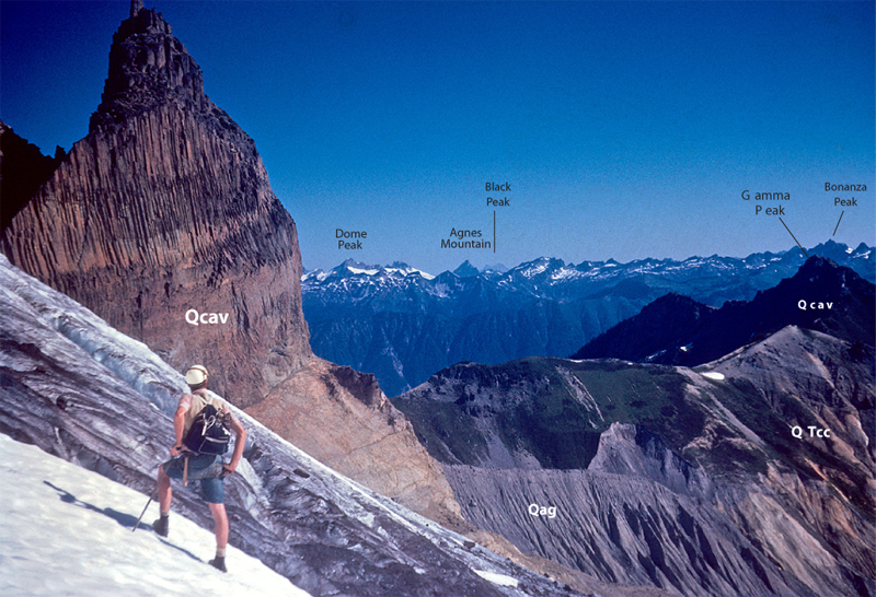
The USGS website Rowland created around this map features an interactive version with photos that identify the various rock types at vista points you may be familiar with. It's like an anatomy lesson on this patch of hallowed ground. Here's just one spectacular example:

One particularly "cool" map shows how far the ice sheets got during the maximum advance of the last ice age! Here's a thumbnail. CLICK HERE for a full-sized image, and just imagine! The take-away is that the extreme beauty of the peaks of the North Cascades is due in large part to massive glacial action, deepening valleys and sharpening peaks (like the "horn" in the picture above). Glaciers gave the "Pickets" their points!

And don't miss Rowland's classic hiking guide to the North Cascades for those with an interest in geology, now online! Routes and Rocks in the Mt. Challenger Quadrangle You'll find a link to it on the American Alps website's "Field Guide" page.

Monday, November 30, 2009

Irate Birdwatcher DVD now on sale!

Our friends at Crest Pictures just released their latest film The Irate Birdwatcher. It's all about wilderness preservation as told in the words of Harvey Manning, the legendary Northwest conservationist, co-founder of N3C, and prolific author (famous for the 100 Hikes series and the mountaineering bible Freedom of the Hills).

Tom Hammond says:

We had a great turnout at both screenings of the Birdwatcher .. and lots of folks wanted to buy the DVD right there on the spot. Unfortunately, we didn't have it to sell yet. But, we do now and need to reach all those people again who were interested in purchasing it .. plus anyone else!

The movie is most inspiring ... following the man through decades as he unveils the beauty of Washington's wildest places, and discovers the need to stand up and fight for their survival. This DVD would make a perfect gift for any outdoor enthusiast and nature lover.


Here's a video of some excerpts:


If you'd like to buy a copy (or more) you can shop for it here: http://www.crestpictures.com/store.html

Read more about the film at: http://www.crestpictures.com/irate_birdwatcher/

Saturday, November 28, 2009

Field Guide on AmAlps website updated

The American Alps "Field Guide" web page is newly updated with a collection of web links for park visitors to orient themselves for a visit. Also the text was edited a bit. See what you think!
http://www.americanalps.org/fieldguide/index.htm
Scroll down the page for the list of links...


Send us the links to North Cascades websites you like, and we'll add them to the list! Use the "Comments" function here or email them to:
ideas@americanalps.org

Wednesday, November 25, 2009

Giving Thanks for Wild Places

We could certainly think of a few places to add to this list, but The Wilderness Society's blog had a great entry yesterday they call "Giving Thanks for Special Places." It's worth a read. And feel free to enter your comments below on wild places you're thankful for in the North Cascades!


http://wilderness.org/content/giving-thanks


Saturday, November 21, 2009

NCNP 101 - A History Lesson

Original Park Proposal Map Shows Founders Intended More Complete Protection

The Sierra Club published The Wild Cascades: Forgotten Parkland in 1964 (text by Harvey Manning, a lifetime member of N3C). It was an advocacy piece for the establishment of North Cascades National Park (NCNP), one of those large "exhibit format" books that Sierra Club published over the years, seen on many a coffee table.

In the back was a map supplement showing the proposed boundaries of the new Park. Here's a portion of that map, showing what became the area covered by the current National Park and National Recreation Areas:


(Click this thumbnail to see a larger image of it in a new window. Click your browser's BACK button to return here.)

There was no Ross Lake NRA in the proposal, so the protected Park boundaries go to the shore of Ross Lake. The protected area does open up below Diablo, presumably due to City Light's Skagit Hydro Project. At the time, City Light was looking at flooding more of the Skagit and its tributaries, but this is no longer the case, so the Park will come down to Ross Lake on the west side as part of American Alps.

Further south, the original Lake Chelan NRA proposal included a big buffer area up the east side of what is now NCNP's South Unit, and highway SR20 and the Granite Creek valley were inside the Park, up to the passes. The north end of Baker Lake and its eastern shore were entirely within the proposed protected area. All of these are in accordance with American Alps.

So you can see how many of the areas now proposed by the American Alps initiative to "expand" the Park and associated Wildnerness were really part of the original proposal. All the more reason to complete the Park, more in accordance with the vision of the founders!

For a detailed story of all the twists and turns on the road to NCNP, pick up a copy of
Wilderness Alps: Conservation and Conflict in Washington's North Cascades by Harvey Manning, at the N3C Web Store.


Wednesday, November 18, 2009

Holden Mine Cleanup update

Norman Day, the the Holden Mine Remedial Project Manager for the USFS in Wenatchee, wrote recently that the current proposal by Intalco (the mining company currently held responsible) known as Alternative 13M will be released when the full Proposed Cleanup Plan is released, in "early 2010." When it's released, the public will only have 30-60 days of open comment period, during which time 4 public meetings will be held, Day said. He referred to the USFS website on the cleanup, but admitted it hadn't been updated since this summer.

  • We will announce the release of the Proposed Cleanup Plan when it comes out, so you can begin making formal comments. Until then, see the end of this post for the address to send your letters to now.

<< Aerial view of the Holden Mine tailings, deep within an enclave of Glacier Peak Wilderness near Lake Chelan, during the last years of the mine's operation in the late 50s. All of these tailings remain today, leaching toxics.

Meanwhile, maps of Alt 13M's plans for the Holden Village vicinity are being handed-out at open presentations at Holden Village, whose representatives continue to actively negotiate with Italco and the Agencies with the stated goal of achieving the best outcome for Holden Village, including infrastructure improvements and reduced "down-time" for the religious/resort operation. The map shows 13M plans to re-route the creek, which would involve cutting down some old trees in the riparian zone.

We would encourage you to write to Mr. Day and express your concern that he, acting on behalf of the general public, exercise due diligence to see to it that the best environmental outcome is achieved.

Write to:
Norman F. Day
Okanogan-Wenatchee National Forest
215 Melody Lane
Wenatchee, WA 98801
Or call:
509-664-9200
Holden Village has their own site about the mine cleanup. Go there and listen to Norm Day make a presentation to Holden about the remediation plan last summer. He says more here than in his official correspondence, and gives you a feeling for Holden's priorities.

See article "The Holden Mine Cleanup Problem" published in the Spring '09 issue of The Wild Cascades for further background on this issue.

[Image above from David Brower's film "Wilderness Alps of Stehekin" ca. 1957]

Sunday, November 15, 2009

Forest Service Releases EA on Whitechuck River Road

<< Change is the only constant in the Whitechuck valley.


The Forest Service has released an Environmental Assessment for rebuilding the Whitechuck River road in the Darrington Ranger District. Readers may remember previous articles in The Wild Cascades describing the effects of the major 2003 washouts, which totally erased substantial sections of the road, especially its lower reaches. The Whitechuck valley has been a conservation priority ever since the Everett Mountaineers attempted unsuccessfully to spare the valley from the railroad logging which began in its lower reaches in 1927. The road should not be rebuilt, but instead converted to multiuse non-motorized trail. See... http://www.northcascades.org/public_html/TWC_Summer-Fall-09_web.pdf

Tuesday, November 10, 2009

Reiter Foothills Forest Recreation Plan posted for comment!

Washington State Dept. of Natural Resources (DNR) just posted the Reiter Forest recreation management plan for public comment:

http://www.dnr.wa.gov/RecreationEducation/Topics/RecreationPlanning/Pages/amp_rec_reiter_foothills.aspx

The DNR says:
DNR would like to hear from you about the findings and recommendations in the draft Reiter Foothills Forest Recreation Plan. In conjunction with the public review of the plan, DNR is also conducting an official State Environmental Policy Act (SEPA) process. The public comment period runs from November 10 through December 4.

Refer to current and past issues of The Wild Cascades for background on this issue, at the N3C website: http://www.northcascades.org/magazine.html

Friday, November 6, 2009

National Parks Receive Funding Increase

From National Parks Conservation Association:
With help from national park supporters like you over the past several months, the National Park System has just received a significant increase in funding for 2010. Last week, President Obama signed a $32.2 billion Interior and Environment Appropriations bill for the 2010 fiscal year. In this bill, the National Park Service (NPS) received $2.7 billion--roughly $218 million above the 2009 funding level!
http://act.npca.org/ct/r7dEb2F1LXv2/view_online

Presentation at Mountaineers a success

Tom Hammond reported Thursday:
"I gave a (10 min) presentation at the Mountaineers last night. There were more than 150 people in attendance. I brought about 100 AmAlps brochures, and about 40 NCCC brochures (all I had), and all were gone at the end of the evening...

Again, a smashing success."

Thursday, November 5, 2009

Teanaway sub-area plans on hold

The grass in a meadow along Teanaway Road east of Cle Elum waves in the afternoon breeze in a Daily Record file photo. Brian Myrick / Daily Record


ELLENSBURG — An Ellensburg Police Department investigation into the disappearance of public documents has prompted the Kittitas County Board of Commissioners to temporarily suspend the Teanaway sub-area planning process.

The commissioners — Alan Crankovich, Mark McClain and Paul Jewell — announced the suspension of the sub-area planning process Tuesday.

“The commissioners are just int
erested in maintaining an open, transparent process and that’s why we suspended it,” said Jewell, who has attended all of the sub-area planning process meetings. “The county is very much interested in maintaining the transparency and integrity of the process, and we want to make sure it’s not undermined. We need time to figure out what’s going on here and to determine if and when we can move forward.”


[Full article: http://www.dailyrecordnews.com/articles/2009/11/05/news/doc4af32b966f545091100463.txt]


From: Ellensburg Daily Record - Thursday, November 5, 2009 12:23 PM PST

Monday, November 2, 2009

Blanchard Mountain Back in Court

The Chuckanut Conservancy and N3C won a court ruling against DNR last year over its plans to build miles of logging roads and increase logging on Blanchard Mountain. The agency appealed the decision before new lands commissioner, Peter Goldmark, took office. We have asked Goldmark to place the appeal on hold while we negotiate a settlement. He has not been willing to do that and is pursuing an expensive court battle. The appeal goes to hearing in November. Blanchard Mountain is within the largest remaining block of maturing coastal forest left in the greater Puget Sound region. Twenty miles of trails attract tens of thousands of hikers each year. The Pacific Northwest National Scenic Trail passes through the heart of Blanchard Mountain. We need your help to defend our lower court victory! For more info or to contribute, please contact us at www.chuckanutconservancy.org or ncccinfo@northcascades.org.

Thursday, October 29, 2009

AmAlps Presentation at preview of Irate Birdwatcher

Tom Hammond of N3C gave a 10 minute presentation before the movie The Irate Birdwatcher last night to the Issaquah Alps Trails Club. It was a smashing success. He brought 20 American Alps brochures, but there were upwards of 100 people there! Every person wanted one, and they were gone in minutes. Tom reports "They invited N3C back to do a full presentation!"

"The movie The Irate Birdwatcher is the best thing that could happen to the American Alps initiative. It is a wonderful movie with strong messages of conservation, and coupled with a brief American Alps presentation, gets people fired up, and gives them a place to direct the energy generated by the movie -- to American Alps," Tom says. The movie's "...like Ken Burns multiplied by 1,000."
To all of us who wondered where North Cascades Park was in the Burns series, the release of this film couldn't be better timed!

The next showing of the movie is at The Mountaineers in Seattle next Wednesday at 7pm!

www.crestpictures.com/irate_birdwatcher/

Tuesday, October 27, 2009

Your Chance to Help Recover Wolves in Washington State!

The Washington Department of Fish and Wildlife (WDFW) is now taking public comments on the latest draft of their Wolf Conservation and Management Plan. Please attend one of these public meetings:


Oct. 6th Clarkston - Walla Walla Community College Lecture Hall
Oct. 7th Spokane - Spokane Valley Center Place
Oct. 8th Colville - N.E. WA Fairgrounds Ag-Trade Center
Oct. 21st Richland - Pacific NW National Laboratory Auditorium
Oct. 22nd Yakima - Red Lion Hotel—Yakima Center
Oct. 28th Vancouver - Water Resources Education Center
Oct. 29th Aberdeen - Rotary Log Pavilion
Nov. 2nd Seattle - REI Seattle Flagship Store (222 Yale Ave. N.)
Nov. 4th Mt. Vernon - Cottontree Inn Convention Center
Nov. 5th Sequim - Guy Cole Convention Center, Carrie Blake Park
Nov. 9th Omak - Okanogan County Fairgrounds Agriplex
Nov. 10th Wenatchee - Chelan County PUD Auditorium

The latest draft of the Washington State Wolf Conservation and Management Plan still includes conservation goals that are far below those needed to assure a genetically viable wolf population recovery in Washington State. Ramping up control actions (i.e., shooting) and perhaps even allowing hunting when we reach only 15 successful breeding pairs in the state is a recipe for disaster. Prepare your comments using the following bullet points, access more detailed comments through the The Wild Cascades, or contact Jim Davis for the latest on how to respond to the state plan. Encourage WDFW to:

+ Support a more focused and transparent scientific process, conducted by qualified biologists.
+ Delay setting of conservation goals for wolf recovery until adequate scientific information is available to do it right.
+ Implement the moving or translocation of wolves to appropriate wilderness habitat within the state.
+ Emphasize non-lethal techniques for management, such as the use of guard animals and predator deterrent fencing.
+ Invest in programs that educate citizens about wolf ecology and the beneficial role they play in northwest ecosystems.

North Cascades Conservation Update for October 2009.pdf

The Irate Birdwatcher


The Irate Birdwatcher
Wednesday, November 4
7 pm @ The Mountaineers Building,

7700 Sand Point Way NE, Seattle
FREE FILM EVENT


Harvey Manning, a Pacific Northwest writer and legendary conservationist, used his words and actions to open up people's eyes to nature's beauty and to urge them to save it. The Irate Birdwatcher is a film inspired by the written works of Manning, with a focus on wilderness preservation. Manning was the voice of a dedicated band of hikers and climbers who sought to create North Cascades National Park and other wilderness areas. In partnership with Ira Spring, he guided northwest hikers to the lessons and pleasures of the great outdoors through the “100 Hikes” series published by Mountaineers Books.

Join us to celebrate the vision and dedication of a true legend - Harvey Manning. This is a free screening and all are welcome to attend.

Friday, October 23, 2009

Completing the Park: The American Alps Legacy Project

"Where's my Park?"

Oddly enough, most visitors to the North Cascades never actually enter the North Cascades National Park. The North Cascades Highway stays within the Ross Lake National Recreation Area and the scenic highway corridor to the east, which is outside the jurisdiction of the National Park Service. The only car-accessible area of the park is along the upper Cascade River Road leading to the Cascade Pass trailhead.

The beautiful 30-mile scenic Highway 20 corridor from Ross Lake to Early Winters did not receive the long-term protection from development that comes with park designation. Important lowlands, like the Cascade River valley, were excluded from the park. Several pristine valleys including Thunder and Big Beaver Creeks were designated as part of the Ross Lake National Recreation Area, instead of park.

Upper Snowy Lake (above) marks one of the true headwaters of the Skagit River in the US. Just beyond, the snowfields below Mt. Hardy mark the true headwaters of the Methow River--a critical area by any measure. The entire area is unprotected.

VISIT:
www.americanalps.org
www.northcascades.org

Welcome to the new N3C Blog!

Welcome aboard the new blog for North Cascades Conservation Council (N3C) and our American Alps Legacy Project initiative! More to come...